Teck understands that access through or near our operations is important to multiple users and recreational groups. In 2021, we adjusted the No-Unauthorized Entry boundaries at several operations to release land back for public use, while maintaining the safety of the public and our employees. In 2021, a collective total of 634.5 hectares of land was returned for public access at Coal Mountain mine and at Fording River Operations. Elkview Operations eastern boundary was also redrawn to follow the mountain ridgeline for easier access at the higher elevation.

Access Boundaries and Land Management
For your protection and ours, please observe and follow the No Unauthorized Entry, No Shooting and No Hunting boundaries. Mining activities can start avalanches or rockslides without warning. Maps should be used for reference only. Please follow field signage at all times. If wounded game crosses the safety boundary, do not follow. You must contact the site Loss Prevention for further instructions. To prevent spread of noxious weeds please remain on designated trails with vehicles. Thank you for your cooperation.
Fording River Operations: 250.865.5016 or 250.425.4133
Greenhill Operations: 250.865.3098 or 250.865.3042.
Line Creek Operations: 250.425.3112
Elkview Operations: 250. 425.8899
Coal Mountain Mine: 250.425.7390
Printed maps are distributed every year via the Fernie Free Press and local recreational organizations. Copies are also available at the operation gatehouses or at the Social Responsibility Office at 116 Centennial Square, Sparwood.
The Teck lands in the Elk Valley and Flathead are located in ʔamakʔis Ktunaxa, the traditional lands of the Ktunaxa Nation. Both the Ktunaxa Nation and Teck recognize the importance of working collaboratively with communities of interest, user groups and the provincial government to carry out a successful land management strategy.
The lands have been managed as a community asset for several decades and provide important habitat for numerous species, such as grizzly bear, wolverine, badger, elk, lynx, mountain goat, bighorn sheep, westslope cutthroat trout and bull trout. They also hold significant cultural and community value.
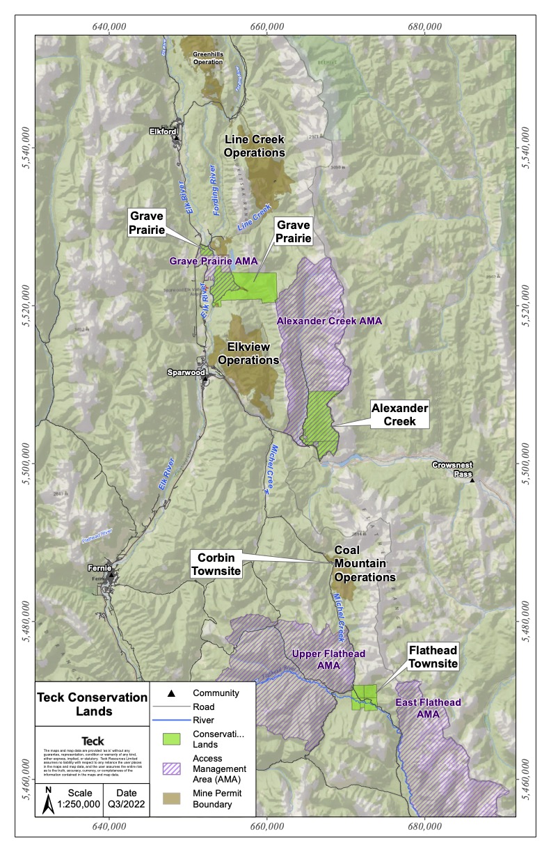 In 2021, the Ktunaxa Nation and Teck signed a Joint Management Agreement for more than 7,000 hectares of land purchased by Teck in 2013 for conservation. The lands are located in ʔamakʔis Ktunaxa and in the region of Teck’s steelmaking coal operations in southeast British Columbia.
Under the Agreement, the Ktunaxa Nation and Teck agree to jointly manage the land for conservation purposes protecting significant fish and wildlife habitat. The Agreement will also support the Ktunaxa Nation Stewardship Principles, and Teck’s goal to achieve a net positive impact on biodiversity in the areas where it operates. Both parties recognize the importance of ensuring that communities of interest are involved in the conservation planning for the lands consistent with Teck’s commitment at the time of purchase.
Image on the left: Map of Teck conservation lands
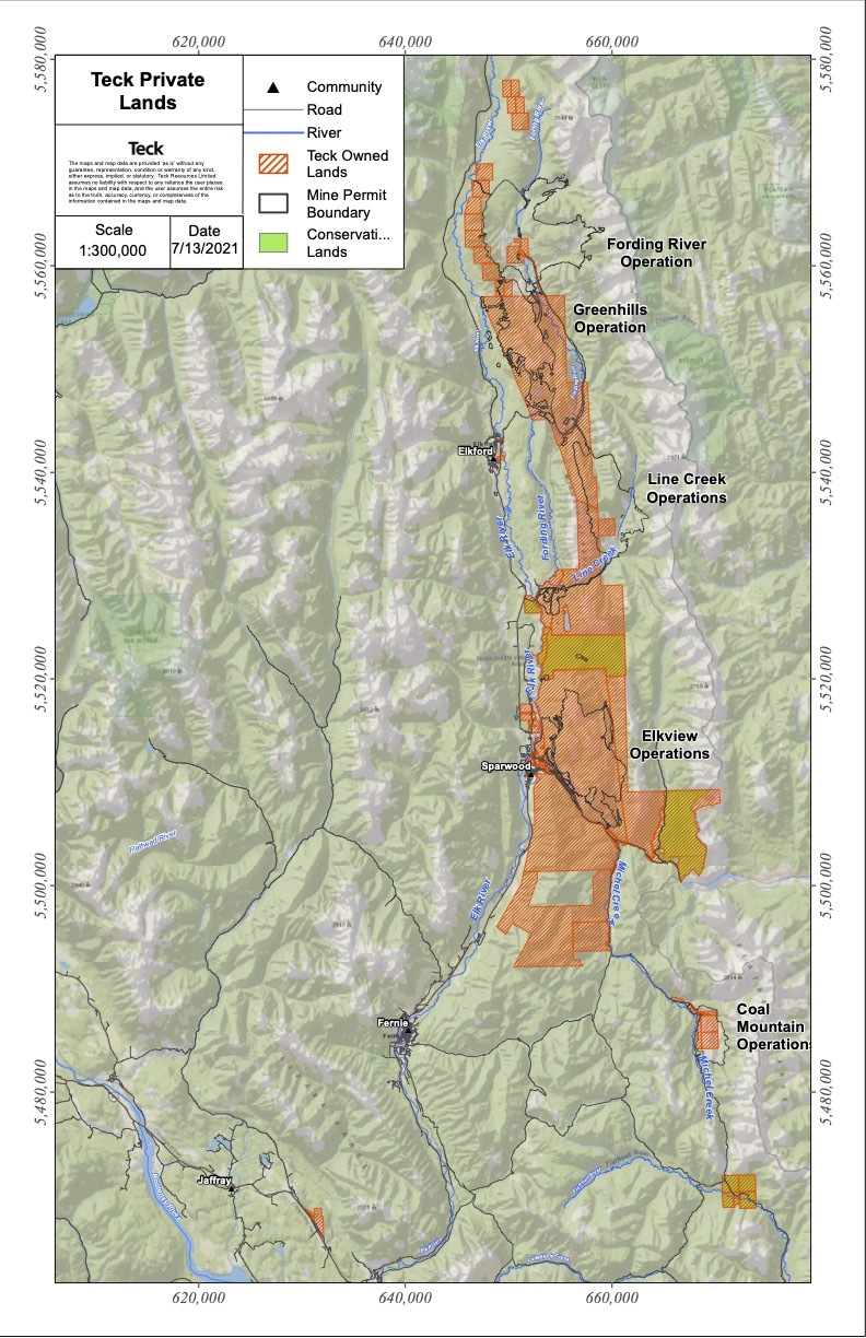 The lands outlined on the map are privately owned by Teck. We welcome and support your responsible use of these lands but ask that you contribute to their integrity and longevity by following the stewardship guidelines outlined in the Teck Private Land Use and Stewardship Information brochure.
Image on the left: Teck private lands in the Elk Valley and Flathead
At Teck, we are working towards securing a net positive impact on biodiversity by maintaining and/or reestablishing self-sustaining landscapes and ecosystems that lead to viable long-term and diverse land uses in the areas in which we operate.
The Elk Valley has a long history of road construction that has resulted in an extensive road network across the landscape. While roads serve an important purpose at the time of development, and subsequently for a variety of reasons, a high concentration of roads has the capacity to result in negative effects on adjacent habitat, ecosystems and wildlife. Road rehabilitation and management strategies are being explored as part of our efforts to contribute towards a reduction in cumulative impacts on regionally valued ecosystems and wildlife.
In 2020, we gathered feedback from individuals, groups, clubs, alliances and organizations to identify an initial 89 km of potential opportunity roads for rehabilitation within the Upper Fording, Henretta Creek, Chauncey Creek, Greenhills Creek and Dry Creek watersheds that should not impact popular recreational use.
What we heard:
-
Start with a focus on roads adjacent to the mines, where possible
-
Maintain traditional recreational routes, trails and access, including horse and foot trails
-
Rehabilitate roads within, or that provide access to ungulate overwintering habitat
-
Consider rehabilitating side roads and spurs off main roads, leaving main routes
-
Incorporate invasive plant treatment
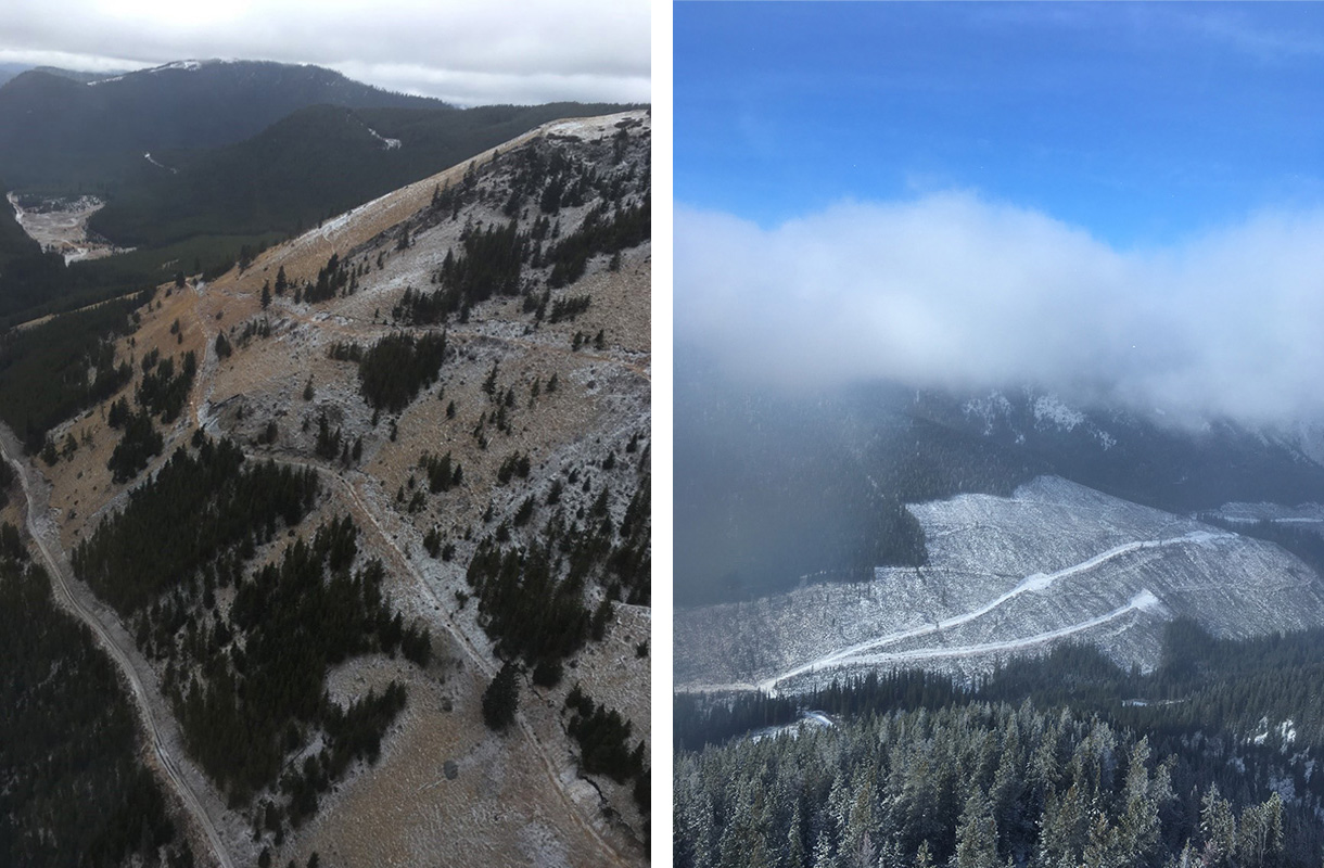
Examples of road networks in the Elk Valley.
Benefits of Road Rehabilitation:
-
Improved habitat quality
-
Reduced wildlife mortality
-
Control, eradication and prevention of invasive plant species
-
Removed vectors for pollution
-
Restoration of hydrological processes and drainage patterns
-
Erosion control and reduced sedimentation into water bodies
-
Reduced habitat fragmentation and alteration of habitats and ecosystems
-
Increased habitat security, availability and quality
-
Minimization of ecological impacts and wildlife disturbance
-
Increased native species and carbon capture through planting and seeding
Understanding that field assessments are still required to evaluate current road condition for the purpose of building out rehabilitation plans for each area, work will aim to fully rehabilitate the area through road fill pullback, slope and material stabilization, invasive plant treatment, water management and revegetation techniques enabling the maintenance of natural surface drainage patterns, minimization of soil erosion, growth of native vegetation, and more. Revegetation will include seeding and planting native plant community compositions similar to the surrounding areas.
For your protection and ours, please observe and follow the No Unauthorized Entry, No Shooting and No Hunting boundaries. Mining activities can start avalanches or rockslides without warning. Maps should be used for reference only. Please follow field signage at all times. If wounded game crosses the safety boundary, do not follow. You must contact the site Loss Prevention for further instructions. To prevent spread of noxious weeds please remain on designated trails with vehicles. Thank you for your cooperation.
Fording River Operations: 250.865.5016 or 250.425.4133
Greenhill Operations: 250.865.3098 or 250.865.3042.
Line Creek Operations: 250.425.3112
Elkview Operations: 250. 425.8899
Coal Mountain Mine: 250.425.7390
Printed maps are distributed every year via the Fernie Free Press and local recreational organizations. Copies are also available at the operation gatehouses or at the Social Responsibility Office at 116 Centennial Square, Sparwood.
The Teck lands in the Elk Valley and Flathead are located in ʔamakʔis Ktunaxa, the traditional lands of the Ktunaxa Nation. Both the Ktunaxa Nation and Teck recognize the importance of working collaboratively with communities of interest, user groups and the provincial government to carry out a successful land management strategy.
The lands have been managed as a community asset for several decades and provide important habitat for numerous species, such as grizzly bear, wolverine, badger, elk, lynx, mountain goat, bighorn sheep, westslope cutthroat trout and bull trout. They also hold significant cultural and community value.
In 2021, the Ktunaxa Nation and Teck signed a Joint Management Agreement for more than 7,000 hectares of land purchased by Teck in 2013 for conservation. The lands are located in ʔamakʔis Ktunaxa and in the region of Teck’s steelmaking coal operations in southeast British Columbia.
Under the Agreement, the Ktunaxa Nation and Teck agree to jointly manage the land for conservation purposes protecting significant fish and wildlife habitat. The Agreement will also support the Ktunaxa Nation Stewardship Principles, and Teck’s goal to achieve a net positive impact on biodiversity in the areas where it operates. Both parties recognize the importance of ensuring that communities of interest are involved in the conservation planning for the lands consistent with Teck’s commitment at the time of purchase.
Image on the left: Map of Teck conservation lands
The lands outlined on the map are privately owned by Teck. We welcome and support your responsible use of these lands but ask that you contribute to their integrity and longevity by following the stewardship guidelines outlined in the Teck Private Land Use and Stewardship Information brochure.
Image on the left: Teck private lands in the Elk Valley and Flathead
At Teck, we are working towards securing a net positive impact on biodiversity by maintaining and/or reestablishing self-sustaining landscapes and ecosystems that lead to viable long-term and diverse land uses in the areas in which we operate.
The Elk Valley has a long history of road construction that has resulted in an extensive road network across the landscape. While roads serve an important purpose at the time of development, and subsequently for a variety of reasons, a high concentration of roads has the capacity to result in negative effects on adjacent habitat, ecosystems and wildlife. Road rehabilitation and management strategies are being explored as part of our efforts to contribute towards a reduction in cumulative impacts on regionally valued ecosystems and wildlife.
In 2020, we gathered feedback from individuals, groups, clubs, alliances and organizations to identify an initial 89 km of potential opportunity roads for rehabilitation within the Upper Fording, Henretta Creek, Chauncey Creek, Greenhills Creek and Dry Creek watersheds that should not impact popular recreational use.
What we heard:
-
Start with a focus on roads adjacent to the mines, where possible
-
Maintain traditional recreational routes, trails and access, including horse and foot trails
-
Rehabilitate roads within, or that provide access to ungulate overwintering habitat
-
Consider rehabilitating side roads and spurs off main roads, leaving main routes
-
Incorporate invasive plant treatment
Examples of road networks in the Elk Valley.
Benefits of Road Rehabilitation:
-
Improved habitat quality
-
Reduced wildlife mortality
-
Control, eradication and prevention of invasive plant species
-
Removed vectors for pollution
-
Restoration of hydrological processes and drainage patterns
-
Erosion control and reduced sedimentation into water bodies
-
Reduced habitat fragmentation and alteration of habitats and ecosystems
-
Increased habitat security, availability and quality
-
Minimization of ecological impacts and wildlife disturbance
-
Increased native species and carbon capture through planting and seeding
Understanding that field assessments are still required to evaluate current road condition for the purpose of building out rehabilitation plans for each area, work will aim to fully rehabilitate the area through road fill pullback, slope and material stabilization, invasive plant treatment, water management and revegetation techniques enabling the maintenance of natural surface drainage patterns, minimization of soil erosion, growth of native vegetation, and more. Revegetation will include seeding and planting native plant community compositions similar to the surrounding areas.
Fording River Extension Project
The Fording River Extension Project (FRX) is a proposed extension to the existing Fording River steelmaking coal mine located in the East Kootenay region in southeastern British Columbia. The Project represents an opportunity to extend the lifespan of our existing Fording River Operations and maintain the jobs and economic benefits generated by the operation in a socially and environmentally responsible manner. FRX is currently in the design stage. During this stage, Teck is defining specific aspects of the Project design using feedback gathered from local communities, Indigenous Peoples and government agencies. Learn more about the future of Fording River Operations at fordingriverextension.www.teck.com
We Want Your Input
Improving access near our boundaries was made possible because of feedback and active participation from local community members. We would like to understand more about how access near or through our operations is important to you. Your feedback will continue to inform access efforts in the Elk Valley.
As backcountry users and outdoor recreationalists, your input on trail and land access located on or through Teck land is valuable. As we revisit our No-Unauthorized Entry Boundaries in relation to our evolving mine planning, we want to understand the areas of interest to you, and how we can help facilitate continued safe use of these areas.
If you have any questions or feedback about our Elk Valley operations, please contact Teck through the Feedback Mechanism by phoning toll-free to 1.855.806.6854 and leaving a message, or by sending an email to feedbackteckcoal@teck.com
For more information about upcoming engagement opportunities, please email communicationsteckcoal@teck.com, or watch for advertisements on Facebook or visit www.teck.com/access.
Related Links
We Welcome Feedback
You can provide feedback about Teck's operations in the Elk Valley via phone at 1.855.806.6854 or via email to feedbackteckcoal@teck.com.
Feedback can be left anonymously but if you leave your contact details we will always follow up with a response.


